Rainfall Roulette: El Niño and Arabian Sea Cyclone Fuel a Bearish Monsoon
The monsoon plays the role of the finance minister of India—as it regulates the social and economic conditions in a large way. Despite an improvement in the irrigation infrastructure, almost 50% of agriculture (15–20% of India’s GDP) is still rain-fed. Anything that disrupts the monsoon will disrupt our day-to-day lives too. Whether you are driving on the road or flying in the sky or awaiting your mango of the season, erratic monsoon can derail all of that. Alas, this is the exact predicament we find ourselves in today.
Halfway through the first month of the monsoon season, India is now looking at a bearish start, grappling with a 53% deficit in rainfall. An El Niño in the Pacific is pulling down the monsoon and an extremely severe cyclone is driving the precious moisture away. El Niño—warm waters in the Pacific—generally weakens the trade winds, dampens the monsoon circulation, and gives reduced rainfall to the Indian subcontinent.
El Niños usually peak during Christmas time in December, a reason why they derive their name from the Spanish term for “little boy”. As oceans absorb more than 93% of the additional heat from global warming, El Niños are also getting stronger. They are not little boys anymore, but monsters of the sea. This June, the warm waters are already in place and are formidable enough to affect the monsoon. A typical impact is a delayed monsoon—as we witnessed this year.
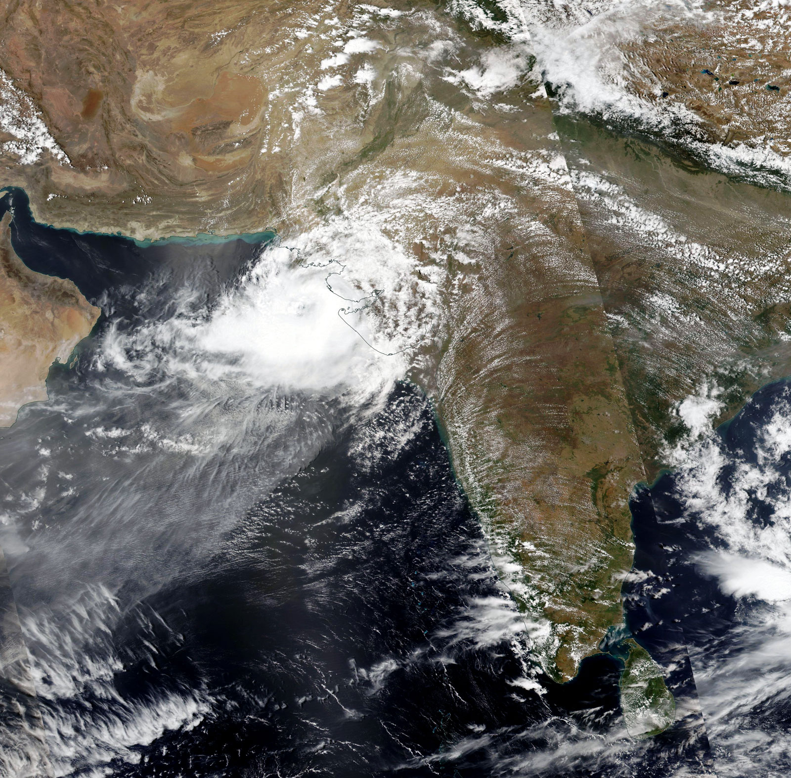
Cyclones do not generally form over the seas when the monsoon is strong, as the winds prevent the vertical development of the storm. This time, a weak and delayed monsoon onset, along with an exceptionally warm Arabian Sea, made it favorable for the formation of Cyclone Biparjoy. The Arabian Sea surface temperatures were 2-4°C above normal, supplying extra heat and moisture necessary for an intense cyclone.
As the seas warm, we see more cyclones forming close to the monsoon onset, interfering with the progression and distribution of the rains. Depending on where it forms and the track it takes, cyclones can either enhance or suppress the progression of the monsoon. Cyclone Biparjoy formed in the south-central Arabian Sea, far away from India’s west coast, driving the moisture away from the mainland. This has resulted in fewer rains over the land.

After moving north, however, the cyclone moved towards India and Pakistan, with a landfall between Gujarat and Karachi. The monsoon also got pulled northward in spurts, with the rains mostly confined to the coastal strip. As the storm moves over land, the remnants will bring some showers to Delhi and neighboring Nepal, just like cyclone Tauktae did in 2021. While the cyclone pulls away the monsoon moisture towards its core, it also results in dry air in other regions causing heatwaves. Central and east India is experiencing severe heatwave conditions.
During the past half century or so, we see a clear climate shift in the weather patterns over India. Monsoon patterns have changed, from rains spread moderately through the season to long dry periods and heavy rainfall events that cause floods. Arabian Sea cyclones have increased by 50%, while their lifespan has increased by 80%. Apart from impacts over the land, this increased lifespan also cut down the number of fishing days, affecting food security and livelihoods. Cyclone Biparjoy now has the record of the longest duration cyclone in the Arabian Sea at 10 days, compared to an average of 4-5 days.
The steadfast rise in these severe weather extremes is in response to the 1°C rise in global temperatures due to historical carbon emissions. All these events are projected to intensify further since the commitments from global nations are insufficient to keep the temperature rise from hitting 1.5°C by 2040 and 2°C between 2040–2060.
In the case of Cyclone Biparjoy, forecasts and disaster management at the ground are saving lives, by evacuating people. Though lives are saved, property, infrastructure, agriculture, and livelihoods are lost with these cyclones. While the number of fatalities has decreased, economic loss due to extreme weather events like cyclones has increased (cyclone Amphan resulted in 14 billion dollars in economic loss). We need to build climate-resilient infrastructure and disaster-proof our coastal cities and districts keeping in mind that these storms are going to intensify further in the near future.
Meanwhile, the monsoon may pick up its bullish spirit by end of the June, as per forecasts. Despite the El Niño weakening the monsoon flow, we should still be prepared for heavy rains and floods that may arrive during the peak of the monsoon. Keep a watch on the weather bulletins and stay safe.
Originally published in MoneyControl [link]


